

What we do
To deal with floods, solutions that did not fully considered the phenomenon and its origins were often privileged in the past. In this old scheme inherited from the 20th century, decisions were usually taken at a high level by experts, rarely integrating the knowledge and the experience of key actors. However, the LocAll4Flood project is implementing an Integrated Multi-stakeholder Governance Model (IMGM) to tackle flash floods. It is integrated because the prevention, adaptation and mitigation actions are not approached separately, but together within a unique system. It provides multi-stakeholder approach because it relies on a bottom-up method, based on dialogue with a variety of entities and populations concerned to build shared solutions.
In the field of floods prevention, the LocAll4Flood project will propose an Early Warning System to provide anticipated information about flooding events. This system will use both hazard data from Pan-European platforms and local data.
With regard to flood adaptation dimension, the LocAll4Flood project will focus on social awareness and education, and will be carrying out surveys to evaluate the risk perception centred on flash floods. The results will be used as a basis to design and implement participatory education actions.
With regard to flood mitigation, the LocAllf4Flood project will conduct an extensive review about the Nature Based Solutions to reduce the risks of flash floods. These potential solutions will be analysed in order to detect the main barriers that hamper their implementation and affect their effectiveness.
LocAll4Flood project will propose a scheme defining the position, responsibilities and interaction of each of the stakeholders involved in flash flooding.
The Integrated Multi-stakeholder Governance Model built by the LocAll4Flood project will be tested and adapted in 9 small representative catchments scattered across the northern Mediterranean sea basin. The results of the LocAll4Flood model will be capitalised in order to facilitate their adoption by other territories in the Euro-Mediterranean region.
CATCHMENTS
Gurri
Torrent Gros
Torrent de na Bàrbara
Kamchia-Varna

Dalgopol
Burmarrad
Birkirkara-Msida
Bari
Anthemountas

More details about our catchments
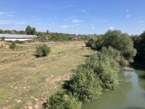
GURRI
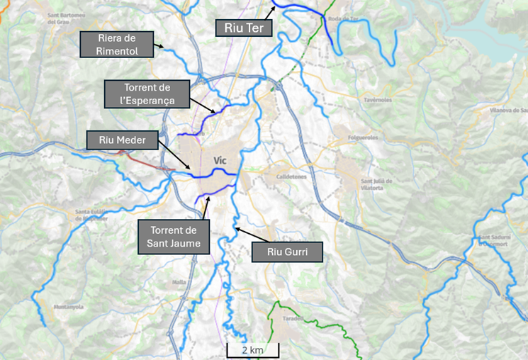
The Vic-Gurb pilot area includes the Torrent de l’Esperança, the Riu Mèder, and the Torrent de Sant Jaume. These river reaches constitute a section classified as high flood risk according to the Catalan Water Agency (TRI ES100100-060), which is included in the Flood Risk Management Plan for the Catalonia River Basin District. This section is located within the municipalities of Vic and Gurb, within the Osona region in Catalonia, Spain.
Several historical flood events have impacted the pilot area, causing varying levels of damage to infrastructure, properties, and human lives, highlighting the area’s vulnerability. This damage is mainly caused because the stream reaches that comprise this section flow through urban and industrial areas, densely populated. During heavy precipitation events, high volumes of floodwaters pass through these reaches, which have limited hydraulic capacity because they are in consolidated urban and industrial areas. Although these flood events are infrequent, they pose a risk to both infrastructure and densely populated residential areas. Furthermore, the economic impact is significant, as the industrial zones in Vic and Gurb, crossed by the stream reaches included in our pilot, are vital to the local economy. The Catalan Water Agency has identified a total of 7.19 km of river stretches potentially affected by flood events within the urban and industrial areas of the Vic’s municipality, an important economic driver of the region, and estimated that the costs generated by these episodes would range between 2.7 and 92.1 M€ depending on the flood return period (from 10 to 500 years). Moreover, the cost in terms of human life has been estimated ranging between 8 and 63 potential losses, considering the same flood return periods. Due to this vulnerability, public administrations in the area are committed to reducing the flood risk associated with flash flood events and have shown their interest in the project and the proposed actions.
In this pilot site, the integrated flood management strategy proposed by the Locall4Flood project, which integrates adaptation, mitigation and prevention measures, could be effective in reducing the identified risks caused by flash floods in the area. Specifically, as states in D.1.1.1 Definition of the 4 Topographical Areas of the Mediterranean Most Commonly Affected by Flash Floods, prevention (improved forecasting tools and early-warning systems) and adaptation (participatory education actions) actions are crucial to reduce these risks in high flood risk areas dominated by urban and industrial land-use. In addition, our pilot also comprises an extensive rural area upstream the urban-industrial zone, where mitigations actions throughout the implementation of nature-based solutions could be feasible to mitigate flash-flood risks.
BARI
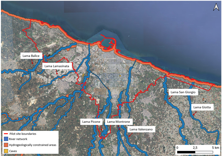
The city of Bari was chosen as a pilot site due to its unique combination of hydromorphological, historical, and socio-economic factors, making it representative of many challenges in reducing flash flood risk.
With a population of 315,653, Bari is the capital of the Apulia region and is located on the Adriatic coast. It represents an important cultural and economic hub for South Italy.
From a hydromorphological perspective, the Bari area is highly permeable and karstic, characterized by ephemeral watercourses known as “lame.” These channels are dry for most of the year but can cause severe flooding after intense precipitation. Urbanization has significantly altered these channels, reducing their hydraulic capacity and leading to significant damage in the past.
Indeed, Bari has a long history of flood events, with significant episodes recorded as early as the 19th century. Notable destructive floods occurred in 1905, 1915, 1926, and more recently in October 2005, causing substantial economic damage and loss of life.
Despite historical evidence of flooding, urban development in Bari has often failed to respect the natural function of the “lame.” This has led to further impermeabilization of the landscape, exacerbating flood risks even in areas far from these channels.
Furthermore, the sporadic and uneven nature of flood effects across the territory contributes to a distorted perception of risk among decision-makers and citizens. This misperception results in behaviors that increase exposure to flood risks, such as inadequate urban planning and insufficient infrastructure.
The combination of Bari’s complex hydromorphological characteristics, historical flood events, ongoing urbanization challenges, and significant socio-economic role makes it an ideal pilot site for the project’s purposes. Addressing these issues in a case study like Bari could provide valuable insights and models for other cities facing similar challenges, ultimately contributing to improved flood risk management, and overall resilience, and inspiring broader policies and planning efforts.
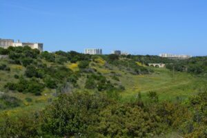
ANTHEMOUNTAS
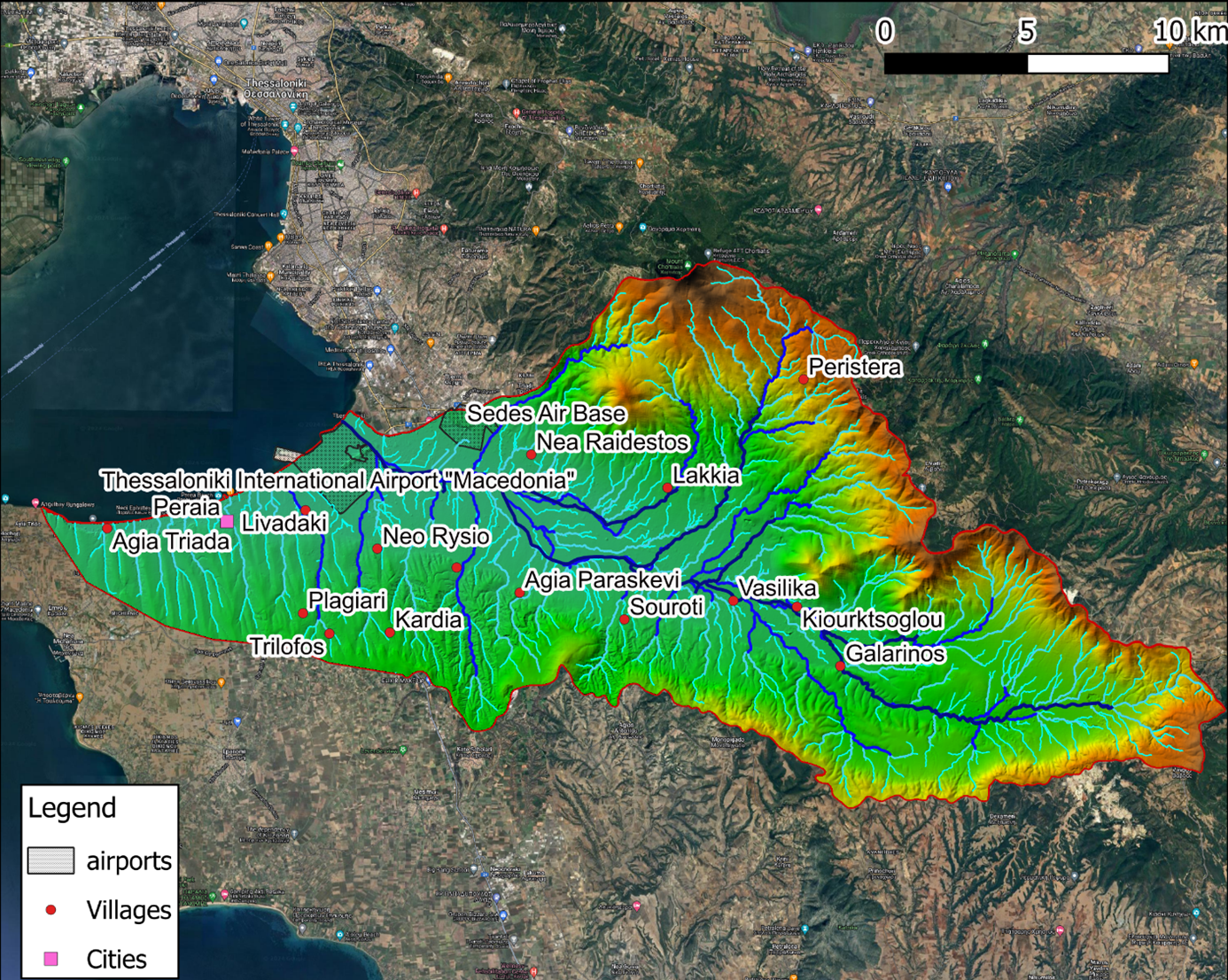
The Pilot site consists of the basin of Anthemountas River, part of the Central Macedonia water district and a coastal area at the east-central Thermaikos Gulf littorals spanning from Macedonia Airport (near Thessaloniki city) to the small town of Agia Triada including the urban area of Peraia, which is vulnerable to coastal floods. It covers an area of 371.22 km² with a population of 60,595 people. The reasons for selecting this area are as follows:
It is classified as a Flood Risk Area according to the Flood Risk Management Plan (FRMP) of Central Macedonia water district. The area is prone to flash floods potentially causing rapid overflow of the river that leads to lowland zone inundation.
It is one of the five main receiving waterbodies of water runoff in the Metropolitan area of Thessaloniki according to its Flood Protection Master Plan.
The main catchment fluvial flow is due to Anthemountas River that outflows very close to the major airport of northern Greece, which is one of the most critical infrastructures in the region.
In recent years, significant flood events have been observed in Anthemountas River, and the construction of flood-protection infrastructure to mitigate inundation impacts is a priority for the broader area.
The broader coastal zone is also under threat from coastal floods due to storm surge impacting its low land elevation areas, while coastal erosion of the sandy beaches is an additional process that enhances flooding risk.
KAMCHIA-VARNA
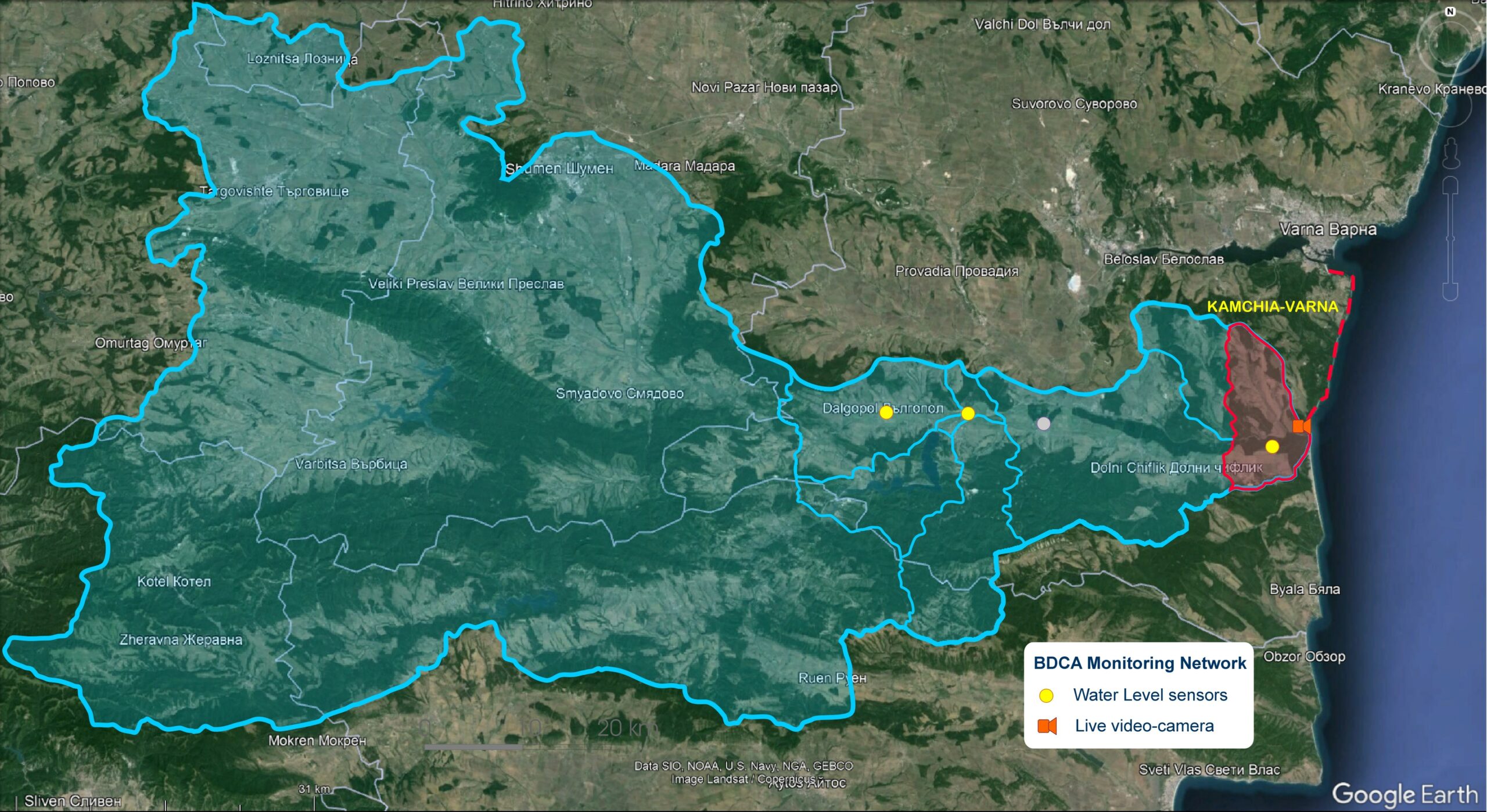
Kamchia estuary catchment is part of an Area with Potential Significant Risk of Flooding (APSFR), included in the Flood Risk Management Plan (2022-2027) of Kamchia River Basin, Bulgaria, code BG2-APSFR-KA-100. The pilot zone include also the adjacent coastal area, from the estuary till Asparuhovo district, Varna, Bulgaria, were heavy flash- flood events in 2014, caused serious impact on peoples, including 14 casualties, as well as a lot of damage on infrastructure and properties.
There is a monitoring network of water level available in this small catchment, including a real-time video-camera for observing the estuary and the touristic sand beach nearby. It makes it suitable for further development of the LocAll4flood Early Warning System.
There are specific Nature-Based Solutions planned in this area, included in the National Program of Implementation of Measures for Flood Protection, with allocated funding from the National Government; Measure M23-B4_2 – Contemporary methods to improve the resistance of residential and non-residential property against floods on the left bank, near the estuary of the river (150 000.00 BGN envisaged.
There are good relations established with the local authorities, municipalities of Dolni Chiflik and Avren, and the Regional Administration of Varna (authority responsible for disaster management).
All the above provide good opportunities for validation of the LocAll4Flood Integrated and Multi-actors Governance Model for flash flood resilience in this pilot area.
DALGOPOL
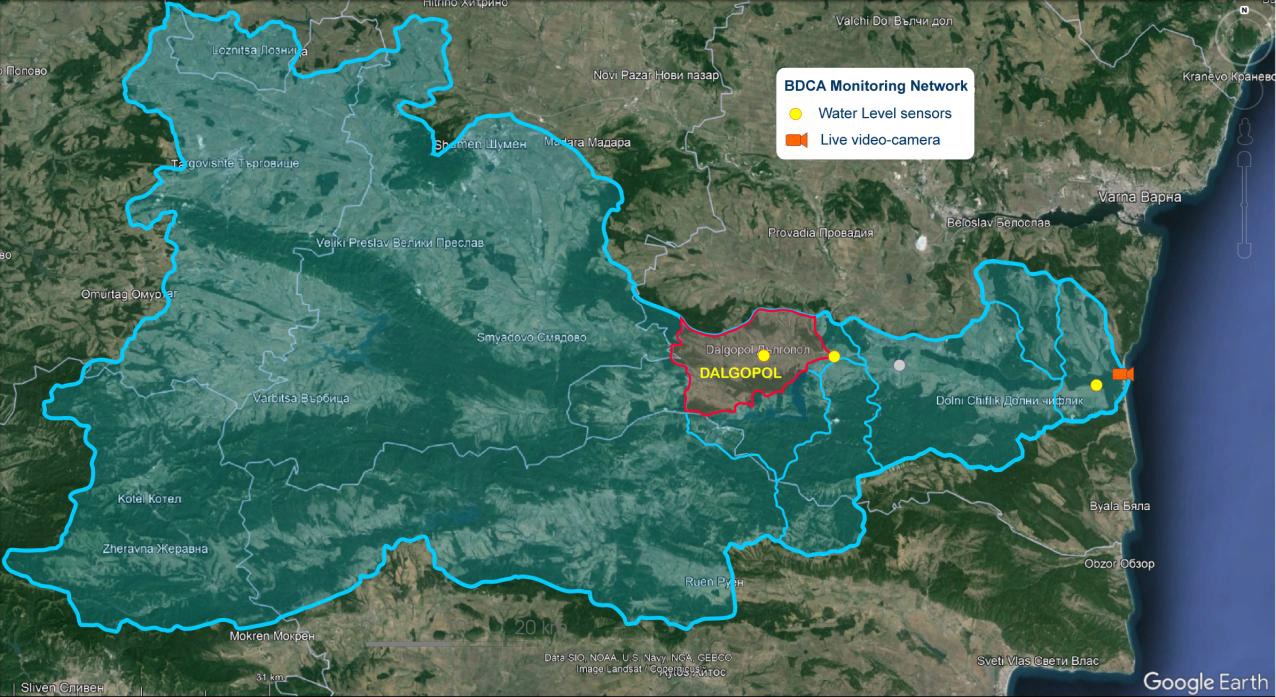
This zone is identified as an Area with Potential Significant Risk of Flooding (APSFR), and included in the Flood Risk Management Plan (2022-2027) of Kamchia River Basin, Bulgaria, code BG2-APSFR-KA-102, according to EU Flood Directive, with “Flash Flood” as main type of flooding. There were heavy flood events in 2015, 2009, 1997, with serious impact on people, and large damage on infrastructure and properties.
There is a monitoring network of water level available in this small catchment, as well as a numerical model established, that makes it suitable for further development of the LocAll4flood Early Warning System.
There are Nature-Based Solutions (water retention measures) planned, included in the National Program of Implementation of Measures for Flood Protection, with allocated funding from the National Government (Flood Risk Management Plan, Cycle 2, 2022-2027).
There are good relations established with the local authorities (municipality of Dalgopol) and Regional Administration of Varna, that provides good opportunities for validation of the LocAll4Flood Integrated Multi-actors Governance Model for flash flood resilience.
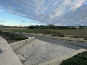
BIRKIRKARA-MSIDA
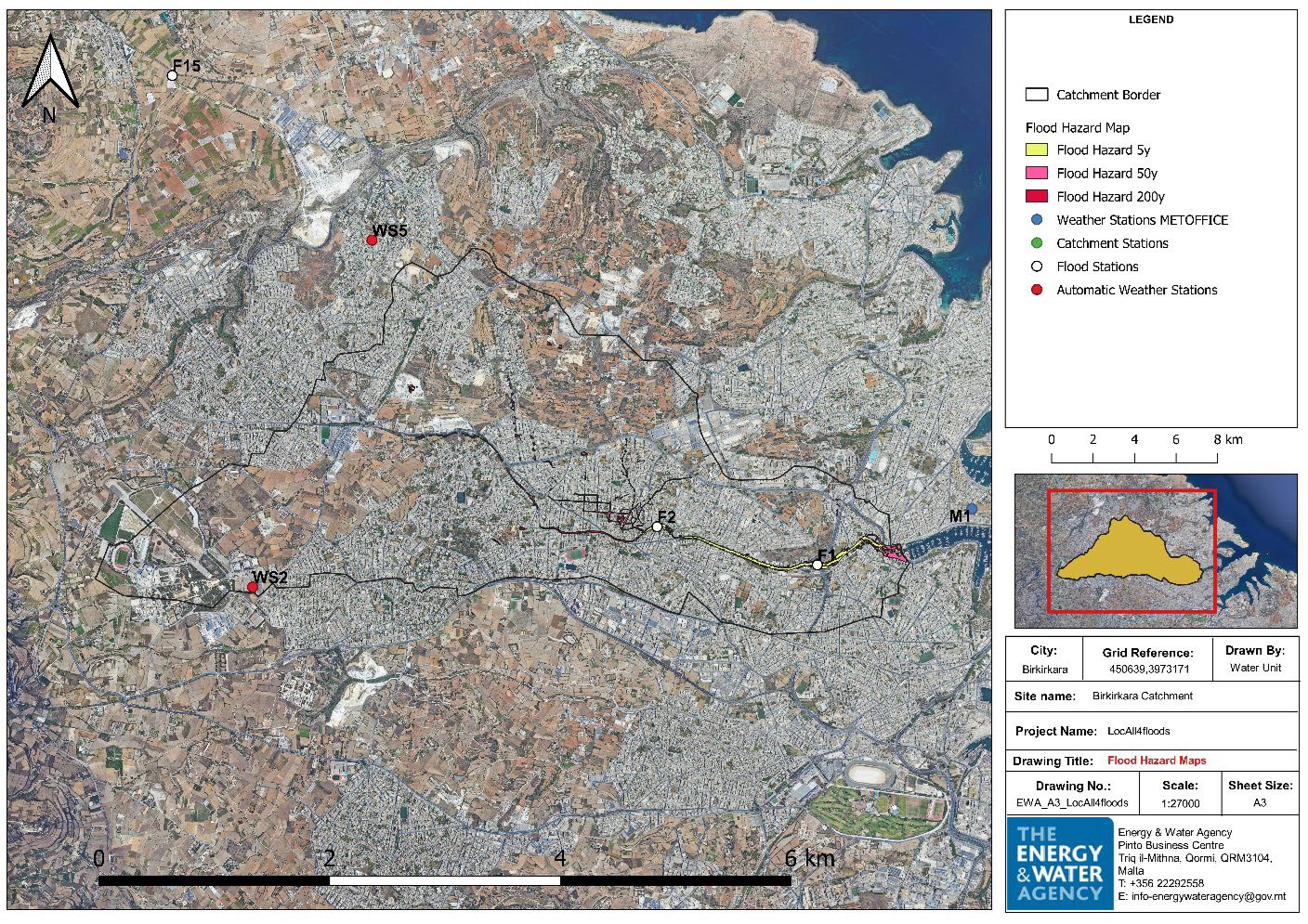
The archipelago of Malta has a total are of 315 km² and is composed of three islands: Malta, Gozo, and Comino. The Malta River Basin District comprises 76 surface hydrological sub-catchments in Malta, 33 in Gozo, one in Comino and coastal waters extending up to one nautical mile from the coast. The Birkirkara – Msida Catchment is recognized as an Area with Potential Significant Risk of Flooding (APSFR) and is included in the Flood Risk Management Plan for the Malta River Basin District. This area is highly susceptible to significant flooding, the main types are the pluvial (caused by heavy rainfall) and flash floods (flooding following intense rain).
Several historical events from the past till now have impacted the community, causing different levels of damage to infrastructures and properties.
The catchment area includes monitoring stations developed during the upgrade of the Hydrological Monitoring Network under PA10 Project to gather hydrological and hydraulic data. The National Hydrological Monitoring Network allows Malta to meet its obligations under the EU Water Framework Directive and Floods Directive by enabling long-term future water resource protection and management for the country.
This monitoring network will enhance the assessment of surface water runoff after extreme events, identify risks to water resources and the environment, and improve the understanding of rainfall patterns. Additionally, it will facilitate more accurate computation of soil moisture, permeability, and rainfall-runoff processes. Within the Birkirkara – Msida catchment area, two types of monitoring equipment have been installed: Automatic Weather Stations and Surface Monitoring systems. Two Automatic Weather stations WS2 and WS5 record meteorological data including precipitation, relative humidity, wind speed and direction, dew point and wind velocity. The Surface Water Monitoring Network comprises two types of stations: C5, which is a catchment station, and F1 and F2, which are flood stations. Catchment monitoring involves streamflow measurements at catchment level, while the floods monitoring focuses on surface water level, flows and downstream monitoring in high-risk catchments.
These stations measure various aspects of water flow, including stream levels, low and high flow rates, and flow velocity. This comprehensive monitoring system is essential for effectively assessing and managing flood risk. Additionally, two weather stations close to the pilot catchment from the Malta International Airport Met Office provide supplementary information on precipitation events in the Birkirkara – Msida Catchment.
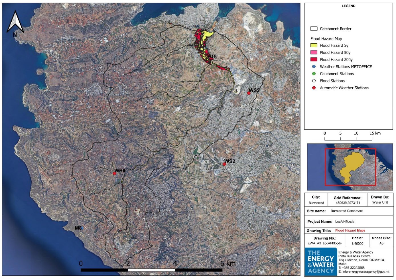
BURMARRAD
The archipelago of Malta has a total are of 315 km² and is composed of three islands: Malta, Gozo, and Comino. The Malta River Basin District comprises 76 surface hydrological sub-catchments in Malta, 33 in Gozo, one in Comino and coastal waters extending up to one nautical mile from the coast.
The Burmarrad Catchment is recognized as an Area with Potential Significant Risk of Flooding (APSFR) and is included in the Flood Risk Management Plan for the Malta River Basin District. This area is highly susceptible to significant flooding, the main types are the pluvial (caused by heavy rainfall) and flash floods (flooding following intense rain).
Several historical events from the past till now have impacted the community, causing different levels of damage to infrastructures and properties.
The catchment area includes monitoring stations developed during the upgrade of the Hydrological Monitoring Network under PA10 Project to gather hydrological and hydraulic data. The National Hydrological Monitoring Network allows Malta to meet its obligations under the EU Water Framework Directive and Floods Directive by enabling long-term future water resource protection and management for the country.
This monitoring network will enhance the assessment of surface water runoff after extreme events, identify risks to water resources and the environment, and improve the understanding of rainfall patterns. Additionally, it will facilitate more accurate computation of soil moisture, permeability and rainfall – runoff processes.
Within the Burmarrad Catchment area, two types of monitoring equipment have been installed: Automatic Weather Stations and Surface Monitoring systems. The two Automatic Weather Stations WS5 and WS6 record meteorological data including precipitation, relative humidity, wind speed and direction, dew point and wind velocity. The Surface Water Monitoring Network comprises the F15, which is a flood station, which monitors surface water levels, flows and downstream conditions in high–risk catchments. This station measures various aspects of water flow, including stream levels, low and high flow rates, and flow velocity. This comprehensive monitoring system is essential for effectively assessing and managing flood risk. Additionally, a weather station closes to the pilot catchment from the Malta International Airport Met Office provide supplementary information on precipitation events in the Burmarrad Catchment.
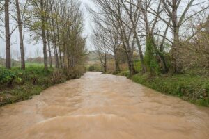
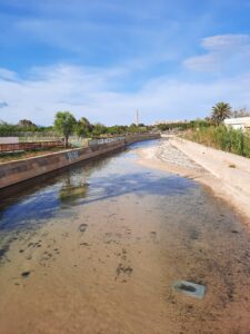
TORRENT DE NA BÀRBARA
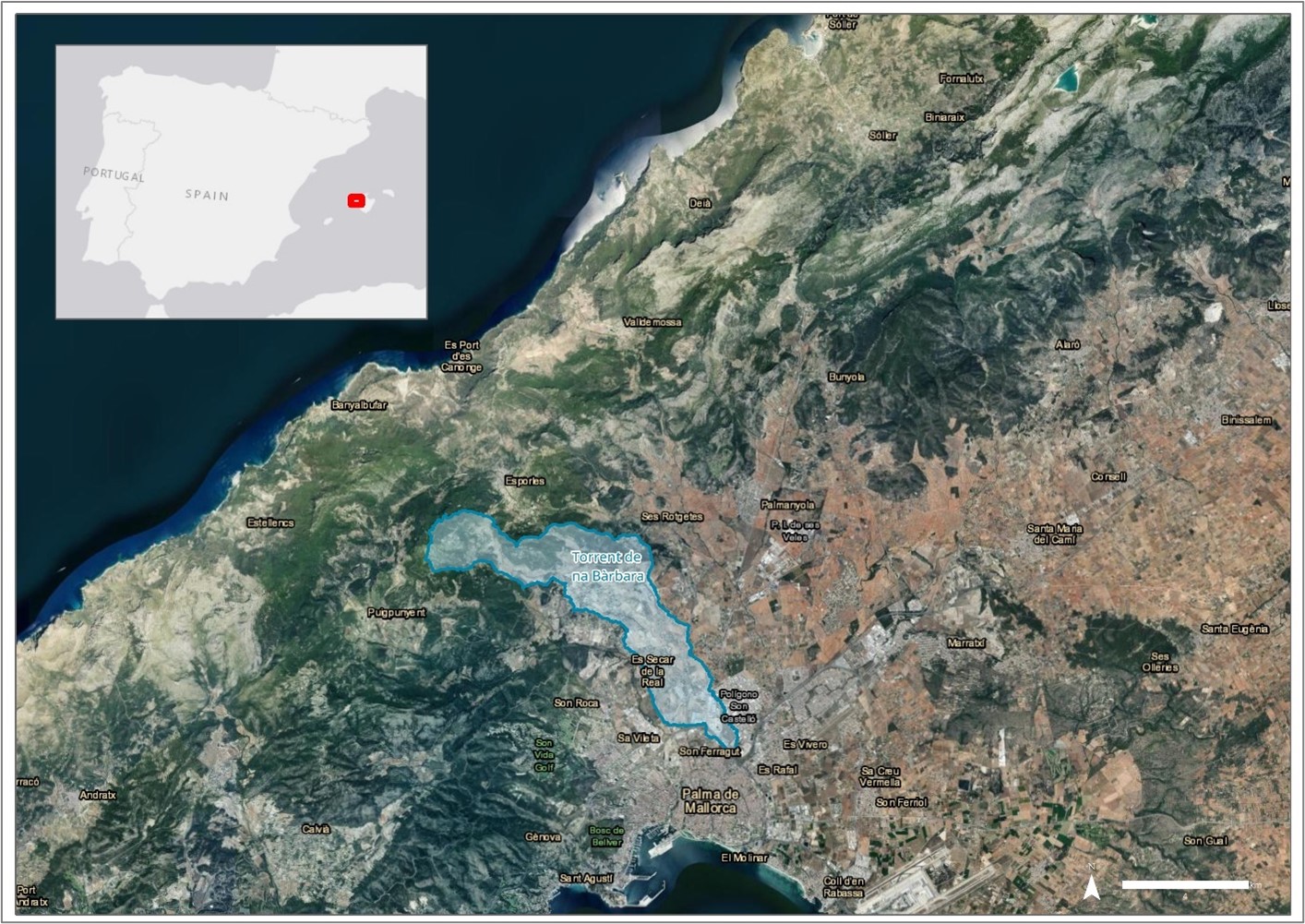
These two catchments have two areas the most potentially threatened by river flooding in the island of Mallorca. The two catchments are located next to each other and the two areas identified with Potential Significant Risk of Flooding (APSFR), and included in the Flood Risk Management Plan (2022-2027) of the Balearic Islands, Spain, the ES110_ARPSI_01301 for the Torrent Gros and ES110_ARPSI_01291 for the Torrent de na Bàrbara. The first one has 2.6 of global hazard and 4.7 of global risk (extreme risk and very high hazard), and the second one has 2 of global hazard and 3.35 of global risk (very high risk and significance hazard). More than 4,500 inhabitants are living in a potentially flooding extreme risk area.
The area has, according to EU Flood Directive, “Flash Flood” as main type of flooding. The two basins have gage stations available, as well as a numerical model established, that makes it suitable for further development of the LocAll4flood Early Warning System.
There were heavy flood events in September 1934 and 1962 with serious impact on people, and large damage on infrastructure and properties. There were other flooding episodes in 2008 and 2010 but not as heavy as in 1962.
There are good relations established with the local authorities (municipality of Palma) and the Autonomous Government of the Balearic Islands, that provides good opportunities for validation of the LocAll4Flood IMGM for flash flood resilience. In these two catchments, the integrated flood management strategy proposed by the Locall4Flood project, which incorporates adaptation, mitigation and prevention measures, could be effective in reducing the identified risks caused by flash floods in the area. Specifically, as states in D.1.1.1 Definition of the 4 Topographical Areas of the Mediterranean Most Commonly Affected by Flash Floods, prevention (improved forecasting tools and early-warning systems) and adaptation (participatory education actions) actions are crucial to reduce this risk in high flood risk areas dominated by urban and industrial land-use.
TORRENT GROS
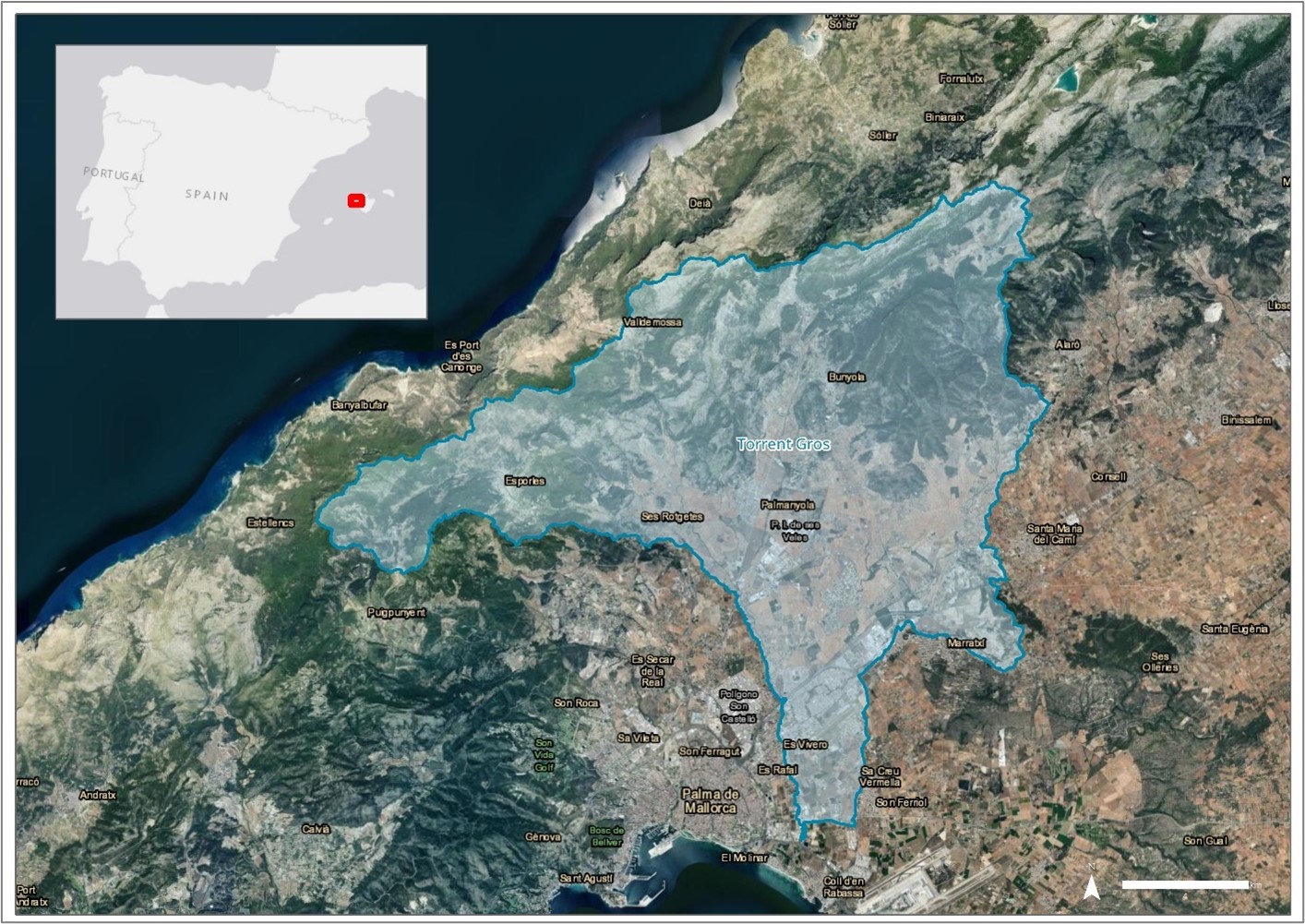
These two catchments have two areas the most potentially threatened by river flooding in the island of Mallorca. The two catchments are located next to each other and the two areas identified with Potential Significant Risk of Flooding (APSFR), and included in the Flood Risk Management Plan (2022-2027) of the Balearic Islands, Spain, the ES110_ARPSI_01301 for the Torrent Gros and ES110_ARPSI_01291 for the Torrent de na Bàrbara. The first one has 2.6 of global hazard and 4.7 of global risk (extreme risk and very high hazard), and the second one has 2 of global hazard and 3.35 of global risk (very high risk and significance hazard). More than 4,500 inhabitants are living in a potentially flooding extreme risk area.
The area has, according to EU Flood Directive, “Flash Flood” as main type of flooding. The two basins have gage stations available, as well as a numerical model established, that makes it suitable for further development of the LocAll4flood Early Warning System.
There were heavy flood events in September 1934 and 1962 with serious impact on people, and large damage on infrastructure and properties. There were other flooding episodes in 2008 and 2010 but not as heavy as in 1962.
There are good relations established with the local authorities (municipality of Palma) and the Autonomous Government of the Balearic Islands, that provides good opportunities for validation of the LocAll4Flood IMGM for flash flood resilience. In these two catchments, the integrated flood management strategy proposed by the Locall4Flood project, which incorporates adaptation, mitigation and prevention measures, could be effective in reducing the identified risks caused by flash floods in the area. Specifically, as states in D.1.1.1 Definition of the 4 Topographical Areas of the Mediterranean Most Commonly Affected by Flash Floods, prevention (improved forecasting tools and early-warning systems) and adaptation (participatory education actions) actions are crucial to reduce this risk in high flood risk areas dominated by urban and industrial land-use.